
INPLAINSIGHT
GIARDINIDELLABIENNALE,VENICE,ITALY
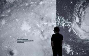
Twice each day, twelve hours apart, a new image of the Earth is captured by the Suomi National Polar-orbiting Partnership (NPP). The 1:30 p.m. diurnal image, assembled from data gathered over a number of days, shows a cloudless “blue marble.” This solitary sphere hovering in space recalls The Blue Marble, the 1972 picture of Earth taken by the crew of the Apollo 17 mission, which quickly became the icon of a unified, borderless, and vulnerable planet. It catalyzed an appeal to global citizenship and heightened concerns over environmental stewardship.
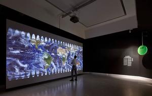
The nocturnal Suomi NPP image, taken at 1:30 a.m., is a “black marble,” a view of lights scattered across the planet’s cloudless surface. Though less textural than the diurnal image, it conveys the extent of humanity’s planetary footprint. According to NASA, it reveals “where the major population centers are and where they are not.”
The multimedia installation In Plain Sight highlights the anomalies — and corresponding perils — of this binary worldview by analyzing Suomi NPP imagery that has been segmented, flattened, and projected onto a large screen floating within a dimly lit space. Combining the data collected by governments and satellite sensors should enable us to identify settlements, estimate populations, and understand the ways that humans organize and occupy the planet — but do the data reflect reality? A “blob detection” programming script identifies discrepancies between NASA’s high-resolution images of nighttime illumination and government-collected population counts. The project interrogates a selection of these algorithmically-detected discrepancies and uses the narrative potential of data to reveal the unseen and untold stories of power and greed — and its victims.
Viewers are first shown places in the world with substantial populations but no illumination. These anomalous sites are classified into one of eight types: wealthy enclaves, refugee camps, power outages, cities denied lighting for political reasons, isolated villages, extraction settlements, informal settlements, and indigenous territories. Wealthy enclaves include Flagstaff, Arizona, a “dark sky community” with a strict light-pollution ordinance. Similarly, locations with bright illumination but no population are also classified into one of eight types: industrial farms, power plants, ports, tourism sites, natural gas extraction facilities, military bases, border zones, and strip mines. Hundreds of examples for each of those sixteen site types are arrayed in a grid of satellite images.
Several powerful stories are told in greater depth through data visualization. In the Democratic Republic of the Congo, for example, the Inga Dams, located in the country’s western region, generate electricity for rare mineral mines in the remote eastern provinces. Both are uninhabited sites that are brightly illuminated at night. A high-voltage power line stretches across 1,700 kilometers of terrain to connect these two points, vaulting over several electricity-deprived cities that consequently do not register on the black marble. These multinational mining operations hoard electricity in order to extract cobalt for use in lithium batteries: the global transition to so-called clean energy is powered at the expense of Congolese citizens.
In the Dominican Republic, the data speak to another pattern of inequality: the country is home to an abundance of high-end tourist resorts while almost a third of its population lives in poverty. Reliable private electricity providers exclusively supply power to more than forty thousand hotel rooms, accounting for 11.5 percent of the country’s annual energy use. At the same time, a parallel public grid that serves millions of citizens is subject to spotty coverage and extensive outages, including villages adjacent to resort cities such as Punta Cana that are regularly left in the dark. This is a global phenomenon: hundreds of tourist destinations around the world are full of lights but devoid of populations and indifferent to the energy scarcity afflicting nearby settlements.
Black marble imagery doesn’t simply represent this world — it actively constructs it. Data is put to work by a variety of political and economic actors to craft policies and interventions organized around binary oppositions, such as urban-rural, developed-undeveloped, rich-poor. According to NASA, uses of black marble imagery include “proxying economic activity, monitoring changes in energy infrastructure in urban areas, and providing data to humanitarian organizations in conflict areas.” In Plain Sight demonstrates that the objective data that lie at the root of wide-ranging policy decisions can be misconstrued. In a world of would-be global citizens, do we truly know where our fellow citizens live? And if we don’t, how can we make them count?

| Location Giardini della Biennale, Venice, Italy |
| Team | Elizabeth Diller,Ricardo Scofidio,James McNally,Cara Roberts,Matthew Johnson,Youxin Chen,and Kumar Atre |
| Laura Kurgan | |
| Robert Gerard Pietrusko | |
| Columbia Center for Spatial Research |